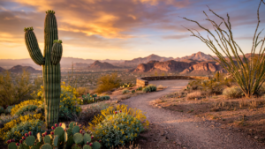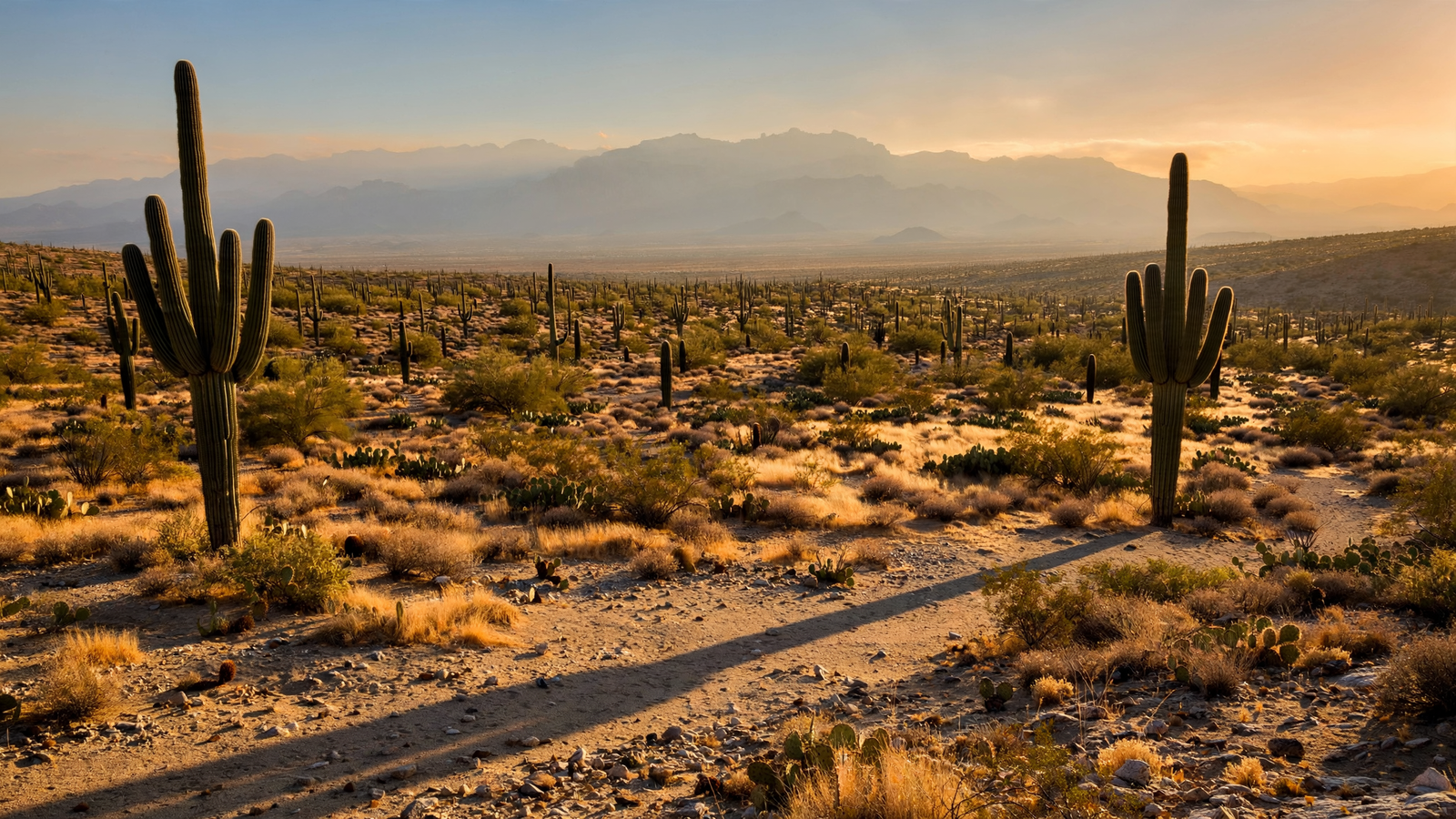
In Tucson, the desert is not something kept at the edge of town. It rises behind neighborhoods, crosses the horizon on a daily commute, and stands in plain view as a forest of tall, branching silhouettes.
That landscape is Saguaro National Park, a two-part preserve on the city’s eastern and western sides. Together, the Tucson Mountain District and Rincon Mountain District protect a broad section of the Sonoran Desert, from dry valley floors to mountain country where the cactus forest gradually gives way to higher-elevation woodland.
The park’s most recognizable residents are, of course, the saguaros. But the larger achievement is the preservation of an entire desert system: the soil that holds it, the seasonal washes that carry rare rainfall, the animals that depend on flowers and fruit, and the human stories that have accumulated around the mountains for thousands of years.
A national park in two halves
Saguaro National Park does not have one central entrance or a single continuous landscape. Its western district lies in the Tucson Mountains, while the eastern district occupies the lower slopes and foothills of the Rincon Mountains. The two districts are separated by the city, but they form one conservation story.
The Tucson Mountain District is known for its dense stands of saguaros and broad views across the desert. Its Bajada Loop Drive offers a close look at the cactus forest, with pullouts and trail access along a route that moves through the foothills. The Rincon Mountain District reaches into a more varied elevation range, with trails that climb from desert vegetation toward pine and oak communities in the mountains.
This change in elevation is central to the park’s character. A visitor can begin among creosote bushes, palo verdes, ocotillos, and saguaros, then encounter a very different world farther up the mountain. In the Rincons, cooler conditions support plants and animals that could not survive on the valley floor.
Protecting that vertical range gives wildlife room to move as conditions change. It also makes the park more than a scenic cactus garden. It is a connected landscape in which water, temperature, geology, and elevation shape where life can persist.
The slow architecture of the saguaro
A saguaro’s height can make it seem permanent, but each cactus is the result of a long and vulnerable beginning. Young saguaros often spend their early years beneath “nurse” plants, such as palo verdes, mesquites, or shrubs that provide shade and some protection from heat and browsing animals.
Growth is slow, especially during the first decades. A saguaro may take many years to reach the height of a person, and its first arm generally does not appear until the cactus is several decades old. Individual plants can live for well over a century, with some reaching an age of 150 years or more under favorable conditions.
That time scale changes the way the landscape is understood. A tall saguaro is not simply a large plant; it is a record of decades of rainfall, drought, cold snaps, competition, and survival. The cactus forest seen from a park road is therefore a living archive, built one season at a time.
Saguaros also support a remarkable amount of life. Gila woodpeckers and gilded flickers excavate nest cavities in their trunks. When those cavities are abandoned, other birds—including elf owls and purple martins—may use them. Flowers and fruit provide food for insects, birds, bats, and mammals during parts of the year.
The cactus’s white flowers bloom in late spring and early summer, usually opening at night and closing during the following day. Their timing connects the saguaro to pollinators that move through the desert after sunset, including nectar-feeding bats. Later, the bright red fruit becomes an important seasonal food source.
A desert shaped by rain
The Sonoran Desert is often described through its heat and dryness, but its biology depends on a distinctive rainfall pattern. Winter storms and summer monsoon thunderstorms arrive at different times, creating more than one opportunity for plants to grow.
Rainfall is uneven and intensely local. One canyon may receive a soaking storm while a nearby neighborhood sees only clouds. When rain does arrive, water can move quickly across hard, rocky ground and through washes. Those brief flows may seem temporary, yet they help recharge soils and create narrow corridors of life.
In Saguaro National Park, those patterns influence everything from flowering and seed production to the movement of animals. They also make the park a place where climate variation is visible. A year of favorable rain can produce a burst of green vegetation; a long dry period can leave the same slopes subdued and spare.
The park’s scientific work tracks these changes over time. Through the National Park Service’s Sonoran Desert Network, researchers and park staff monitor vegetation, birds, mammals, weather, and other indicators of ecosystem health. Long-term monitoring matters because a single season can be misleading. The desert’s future is better understood through repeated observations across many years.
Older than the park boundary
The land now managed as Saguaro National Park has a human history far older than the federal designation. The Tohono O’odham and other Indigenous peoples have longstanding relationships with the Sonoran Desert, including knowledge of its plants, animals, water sources, and seasonal rhythms.
Saguaros have particular cultural importance for the Tohono O’odham. The fruit ripens near the beginning of the summer monsoon season and has traditionally been gathered using long harvesting poles. The harvest is not merely a search for food; it is connected to community, ceremony, knowledge, and the recognition of a new seasonal cycle.
Archaeological evidence in and around the Tucson Basin also records earlier communities that farmed, traveled, gathered plants, and built settlements in this challenging environment. Rock art, tools, irrigation traces, and other cultural resources show that the desert was never an empty wilderness waiting to be discovered.
That history adds depth to the park’s trails. A walk through the cactus forest can be a lesson in ecology, but it can also prompt questions about whose knowledge made survival possible and how people have continued to care for this place.
From monument to national park
Saguaro’s federal protection began in 1933, when the area was established as a national monument. The designation recognized the unusual density and beauty of its cactus forests at a time when Tucson was growing and roads were making more of the desert accessible.
During the 1930s, Civilian Conservation Corps crews helped develop roads, trails, and visitor facilities in the Tucson Mountains. Their work remains part of the park’s built history, although the landscape itself is the reason those facilities matter: they provide access without requiring the desert to be transformed into an urban park.
The protected area expanded over time. In 1994, Congress redesignated Saguaro National Monument as Saguaro National Park, acknowledging the national importance of the desert ecosystem and the larger landscape preserved across both districts.
The designation did not freeze the desert in place. Instead, it created a public responsibility to understand change and respond to it. Fire, invasive grasses, drought, development around the park, and changing temperatures all affect the future of the cactus forest.
Keeping an old landscape resilient
One of the park’s modern challenges is the spread of invasive grasses, including buffelgrass. Native desert plants are adapted to a landscape where fire is relatively uncommon. Dense stands of nonnative grass can create continuous fuel, allowing fires to spread more easily and burn hotter than the desert’s native vegetation evolved to withstand.
Park crews and partners work to locate and remove invasive plants, monitor vulnerable areas, and manage fire risk. This is patient conservation rather than a one-time cleanup. Seeds can remain in the soil, new plants can arrive from outside the park, and conditions after rain can change quickly.
The work is easy to overlook because its success often looks like the absence of a disaster: a wash that remains open, a young saguaro that survives, or a patch of native plants that does not become a carpet of invasive grass. In a landscape that changes slowly, prevention is one of the most important forms of protection.
A public landscape close to home
Saguaro National Park’s location gives it a special role among America’s national parks. It is not remote. Tucson’s streets, homes, schools, and businesses surround the protected lands. That proximity brings pressure, but it also makes the park part of daily civic life.
Residents can visit for a short sunset walk, return to a familiar trail in a different season, or use the park as an introduction to the desert for someone seeing saguaros for the first time. Visitors can follow the scenic drives, walk among the cactus forests, or climb into the Rincon Mountains and watch the vegetation change with elevation.
The best lesson may be the one the saguaros offer without explanation: meaningful landscapes are built on timescales longer than a single visit. A cactus forest becomes possible because many generations of plants survive, reproduce, and make room for the next generation.
On either side of Tucson, Saguaro National Park keeps that process visible. It protects a desert that is both resilient and vulnerable, ancient in its patterns but never static. And it gives a growing city something increasingly valuable: a living landscape large enough to remind people that nature is not elsewhere. It is part of home.