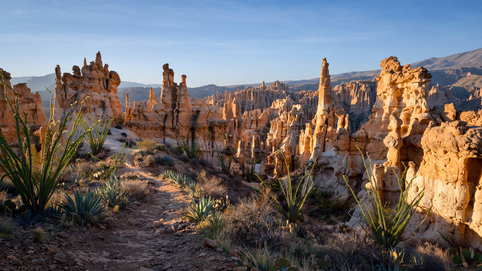
In southeastern Arizona, the land changes almost imperceptibly at first. Desert grasslands stretch toward the Chiricahua Mountains, the horizon rising in long, quiet folds. Then the road enters Bonita Canyon, climbs through oak and pine, and arrives at a landscape that seems to belong to another planet.
At Chiricahua National Monument, volcanic rock stands in towers, columns, fins, and precarious-looking stacks. Some formations resemble people or animals. Others look like ruined buildings, frozen waves, or a city assembled by wind. Together, they create what visitors often call a stone forest—not because the analogy is perfect, but because the monument’s densely packed pinnacles make the landscape feel alive with vertical motion.
The unusual shapes are not the work of a single dramatic moment. They are the result of a long partnership between volcanic fire, fractured rock, rain, ice, gravity, and time. The monument preserves that process in a compact mountain landscape where a visitor can see geology, wildlife, history, and changing elevation unfold along the same road.
A volcano became a mountain of stone
The rocks at Chiricahua began forming roughly 27 million years ago, when a large volcanic eruption sent ash and pumice across the surrounding region. The material settled, compacted, and welded into a hard volcanic rock called rhyolite tuff. Later fractures divided the rock into blocks. Water entered those cracks, widened them, and gradually wore away the softer surfaces.
That erosion left behind the formations that define the monument: narrow spires, walls, arches, and balanced boulders perched on slender bases. The process continues today, although on a timescale far beyond a human visit. Every storm and freeze contributes to the slow reshaping of the rock, even as the larger landscape appears still.
The result is especially striking because the formations are not isolated curiosities scattered across a broad plain. They gather in thick clusters. From overlooks such as Massai Point, the view is less like a single landmark and more like a sprawling stone city extending through the canyons.
Several trails lead into that maze. The Echo Canyon and Hailstone trails descend among towering walls and narrow passages. The Heart of Rocks Loop brings hikers close to some of the monument’s most recognizable formations. The Bonita Creek area offers a different experience, with water, shade, and a corridor where plants and animals find cooler conditions than they do in the surrounding desert.
One monument, several Arizona landscapes
Chiricahua is part of the network of isolated mountain ranges known as the Madrean sky islands. These ranges rise above broad desert and grassland valleys, creating islands of cooler, wetter habitat. The change is visible as the road climbs: desert vegetation gives way to oak woodland, then to higher-elevation forests of pine and fir.
This vertical variety helps explain why the monument supports such a rich mix of life. Visitors may encounter mule deer, white-tailed deer, javelinas, black bears, mountain lions, coatimundis, and numerous bird species. The area is also associated with the Mexican spotted owl and the elegant trogon, a colorful bird whose presence in southeastern Arizona attracts birders from well beyond the region.
Wildlife sightings are never guaranteed, and the animals are not the monument’s display. Their importance is that they reveal how much ecological room can exist inside a relatively small protected area when elevation, water, forest, and desert meet.
That meeting also gives Chiricahua its changing character. A summer thunderstorm can darken the pinnacles and make the rock appear almost metallic. In autumn, oak leaves add warm color to the canyon walls. Winter can bring snow to the higher ridges, emphasizing the contrast between the mountain and the desert below. Spring often brings flowers and migrating birds, though conditions vary from year to year.
A place shaped by people as well as geology
The Chiricahua Mountains are not an empty wilderness separated from human history. They are part of the homeland and history of the Chiricahua Apache people. The National Park Service describes the region as connected to Apache leaders, families, travel routes, and resistance to the expansion of the United States into the Southwest.
The name itself reflects that history. “Chiricahua” is commonly associated with the Chiricahua Apache, although the community’s relationship with the wider region is older and more complex than a park name can convey. A visit is richer when the stone formations are understood alongside the people who knew these mountains as a lived landscape rather than a scenic destination.
Later, the monument became associated with the Erickson family and Faraway Ranch. Neil and Emma Erickson settled in Bonita Canyon in the late nineteenth century, establishing a ranch that eventually became a guest ranch and a gathering place for visitors drawn to the mountains. The historic buildings remain part of the monument’s story, offering a more intimate counterpoint to the immense geology outside.
Faraway Ranch helps show how the meaning of a place can shift over time. The canyon was once a home, workplace, and working landscape. It later became part of a public monument where people come to hike, study, camp, and experience the scenery. Preserving the ranch does not reduce the area to one family’s story; instead, it adds another layer to a landscape already carrying geological and Indigenous histories.
Why protection matters here
Chiricahua National Monument was established in 1924 to protect the remarkable rock formations. Its value, however, is not limited to the pinnacles. The monument protects a connected mountain environment: stream corridors, forests, grasslands, wildlife habitat, historic structures, and dark night skies.
That combination matters because scenic places can be damaged even when their most famous features remain standing. Roads, unmanaged recreation, invasive plants, wildfire, drought, and climate change can alter the conditions that make a mountain ecosystem work. At Chiricahua, protecting the rocks also means caring for the forests and waterways around them.
The monument’s relative remoteness is part of that protection and part of its appeal. It lies about 37 miles southeast of Willcox, reached by a road that leaves Interstate 10 and crosses open country before entering the mountains. There are no large commercial centers inside the monument, and visitors need to plan for fuel, food, water, weather, and limited services before arriving.
That distance can feel like an inconvenience in a culture built around easy access. Here, it works differently. The drive creates a gradual transition from highway travel to a slower, more attentive kind of movement. The destination is not a single overlook reached by car. It is the accumulation of changes along the way: grassland becoming woodland, road becoming trail, and ordinary rock becoming an improbable skyline.
A landscape that rewards attention
Chiricahua does not need to be improved with spectacle. Its power comes from the fact that the formations invite close looking. A distant view reveals the scale of the stone forest, but a trail reveals the details: pockets of lichen, weathered surfaces, roots gripping dry soil, and small shadows beneath rocks that seem too large to balance.
The monument also rewards repeat visits. The same trail can feel different under bright sun, low clouds, fresh snow, or monsoon rain. Morning light can separate the pinnacles into crisp layers, while afternoon shadows deepen the canyons. Even without traveling far, visitors can move between open overlooks and enclosed passages, exposed rock and shaded woodland.
That variety makes Chiricahua one of Arizona’s most complete landscape experiences. It is a geological record that can be walked through, a mountain refuge surrounded by desert, and a historic place whose meaning reaches beyond scenery.
Most of all, the monument offers a useful reminder about time. The formations took millions of years to become recognizable, while a human visit may last only a few hours. Yet those hours are enough to make the long process visible. In Chiricahua, erosion is not merely wearing a mountain away. It is revealing a world.