For much of the 20th century, the Saw Mill River was easy to miss in downtown Yonkers, New York. The waterway still moved toward the Hudson River, but in the center of the city it ran beneath pavement, buildings and parking areas. A river that had helped shape the community had become almost invisible.
Then Yonkers began uncovering it.
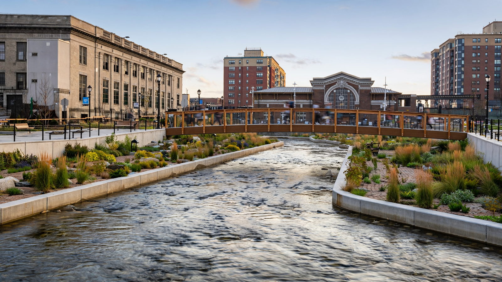
Today, the river flows in the open through Van der Donck Park, a compact public space in the heart of downtown. Water passes beneath footbridges and alongside planted edges, while people sit, walk, eat and gather nearby. The result is more than a park project. It is an example of how a city can repair its relationship with a natural feature that urban development once pushed out of sight.
A river beneath the city
The Saw Mill River runs for roughly 23 miles through Westchester County before reaching the Hudson in Yonkers. Its name reflects an earlier era, when the river powered mills and supported industry. Long before the modern city took shape, the waterway was part of the landscape used by Indigenous people and later became an important resource for European settlers.
As Yonkers industrialized, the river became increasingly associated with factories, roads and flood-control infrastructure. In the downtown area, sections were channelized and covered. Burying the river made it possible to build over the stream, but it also removed a visible piece of the city’s identity.
That pattern was common in American cities. Streams were often treated as obstacles, drainage channels or sources of industrial power. When water became polluted or difficult to manage, putting it underground appeared to offer a clean solution. Over time, however, buried waterways could contribute to flooding, weaken connections between neighborhoods and erase the history of a place.
Yonkers eventually began to consider the river not as leftover infrastructure, but as a foundation for downtown renewal.
Daylighting a forgotten waterway
The central idea was “daylighting”: removing the structures that conceal a stream and allowing it to flow in the open air again. In Yonkers, the first major downtown phase exposed approximately 800 feet of the Saw Mill River. The newly visible channel became part of Van der Donck Park, named for Adriaen van der Donck, an early settler whose sawmill stood near the river in the 17th century.
The work was not simply a matter of taking away concrete. Engineers had to manage stormwater, protect nearby buildings and streets, stabilize the riverbanks and create a public space that could withstand the pressures of a dense urban district. The design also had to make the river accessible without turning it into a decorative pool disconnected from natural processes.
That balance is visible in the finished park. The channel is shaped and engineered, but it remains recognizably a moving stream. Paths and crossings bring people close to the water. Plantings soften the edges and provide habitat. Steps and seating give the park an everyday civic role: it is a place to pause, meet friends, eat lunch or pass through on the way elsewhere.
The project opened a new view of downtown. Instead of treating the river as something to hide, Yonkers made it the center of the public realm.
What a visible river can do
The most immediate change is visual. A covered stream is easy to ignore; an open one gives a neighborhood a distinct center. In Van der Donck Park, water provides movement, sound and seasonal change in a part of the city otherwise dominated by buildings and traffic.
But daylighting can also serve practical purposes. An open channel gives stormwater a defined path and can be designed with room for changing flows. Vegetation and carefully chosen surfaces can help slow runoff and reduce the amount of water rushing directly into underground pipes. The precise benefits depend on the design and the larger drainage system, but the principle is straightforward: water is easier to understand and manage when a city makes space for it.
The river also offers an opportunity for ecological recovery. A restored urban stream is not the same as a wilderness waterway, and Yonkers’ downtown channel remains highly designed. Still, removing some barriers, improving habitat and reconnecting the river to daylight can create better conditions for aquatic life than a dark conduit beneath a street.
Perhaps just as important, the park makes environmental history visible. Visitors do not need to study a map to learn that the city grew around water. The river itself explains why the district developed where it did, why mills once operated nearby and why flood management remains part of the city’s story.
From waterfront project to civic space
Yonkers’ river restoration took place alongside a broader effort to reconnect downtown with its waterfront. For decades, transportation infrastructure, industrial uses and neglected parcels had separated many residents from the Hudson River. The Saw Mill River project created a smaller but more immediate connection: a public landscape woven into the daily life of the city.
That distinction matters. A waterfront can be impressive as a destination, but a neighborhood park succeeds when people use it routinely. Van der Donck Park is close to shops, restaurants, offices, housing and transit. It does not require a special outing. The river is encountered as part of ordinary urban life.
Projects like this can also change how residents imagine future development. Once a buried stream is visible, it becomes harder to think of the surrounding land as an interchangeable expanse of pavement. The waterway gives the district a sense of place and creates a reason to invest in paths, public seating, planting and nearby streets.
That does not mean every result is automatically beneficial or evenly shared. New public amenities can raise property values and attract development, sometimes creating affordability pressures. A successful park must therefore be considered alongside housing policy, public access and the needs of existing residents. Daylighting is a tool, not a complete solution to urban inequality.
Even with those questions, Yonkers demonstrates the civic potential of restoration. A project can improve a landscape without moving people out of the city or building an entirely new district. It can begin with something already present—water—and ask what becomes possible when that feature is respected rather than concealed.
A model for seeing cities differently
Yonkers is part of a wider movement to uncover urban streams. Cities including San Francisco, Portland, Seattle and Providence have explored daylighting or restoring waterways that were buried, straightened or confined. Each project has different environmental and engineering conditions, but the underlying lesson is similar: old infrastructure can be reconsidered when a community’s priorities change.
Not every buried stream can or should be exposed. Some run beneath critical buildings, major roads or heavily contaminated sites. In other places, flood risk, land costs or water quality make daylighting impractical. Restoration must be based on careful hydrology and long-term maintenance rather than on appearance alone.
Yonkers’ achievement is not that it returned downtown to an untouched natural condition. It did something more relevant to a modern city: it created a useful relationship between engineered infrastructure, public space and living water.
The Saw Mill River was never truly gone. It continued beneath the city, carrying water toward the Hudson. What changed was the city’s willingness to see it again. In bringing the river into the open, Yonkers recovered a piece of its past and turned it into part of its future—a reminder that urban renewal sometimes begins by uncovering what was already there.