Seen from Prescott, Thumb Butte looks almost like a raised hand against the sky. Its rocky summit stands above the city’s western edge, a familiar landmark for residents and a first introduction to the high country for many visitors. Yet the mountain is more than a scenic backdrop. Its trails pass through a meeting place of ponderosa pine forest, chaparral, granite outcrops, open grass, and the broad light of central Arizona.
That combination gives Thumb Butte an unusual role in Yavapai County. It is close enough for a short outing from town, but once hikers begin climbing, the roads and buildings quickly fall away. The landscape becomes a compact lesson in elevation, water, fire, wildlife, and the ways public land can serve both everyday recreation and long-term conservation.
A landmark at the edge of Prescott
Thumb Butte Recreation Area is managed by the Prescott National Forest, part of the larger federal forest surrounding Prescott and extending across a varied portion of central Arizona. The recreation area lies only a few miles west of the city, making it one of the community’s most recognizable gateways to public land.
Its closeness matters. Many western landscapes require a long drive before a visitor reaches a trailhead. Thumb Butte does not. A person can leave downtown Prescott, pass from neighborhoods into open country, and arrive at a forested mountain in a relatively short time. That accessibility has helped make the area part of ordinary local life rather than a destination reserved for vacation trips.
The mountain is also part of Prescott’s visual identity. From town, the distinctive summit helps define direction and distance. From the trail, the view reverses: Prescott appears below as a community set within a basin of ridges, trees, roads, and dry terrain.
What changes during the climb
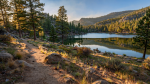
The central trail system is short enough for a half-day outing, but the experience is shaped by a noticeable change in elevation. The lower slopes can feel open and sun-washed, with shrubs and grasses occupying spaces between rocky ground. Farther up, ponderosa pines become more prominent, bringing shade, resinous scent, and cooler pockets of air. For related reading, see Thumb Butte: The Prescott Landmark That Keeps a Working Forest Close.
That transition is one reason Thumb Butte is useful as an introduction to Arizona’s uplands. The state is often imagined through desert scenery, but central Arizona contains a series of ecological zones stacked across changes in elevation and moisture. Around Prescott, a visitor can encounter desert-influenced vegetation, oak woodland, pine forest, and exposed granite within a relatively small area.
None of those communities exists in isolation. Rain and snow that fall on higher ground can move through soil and rock toward lower basins. Trees influence shade and soil moisture. Fire changes the structure of forest and grassland. Wildlife moves between cover, feeding areas, and water sources. A short trail can therefore reveal a much larger system: the mountain is not simply a scenic object, but part of a watershed and a living landscape.
Granite, weather, and the shape of the mountain
Thumb Butte’s character is inseparable from the hard rock beneath it. Central Arizona’s uplands are marked by granite formations shaped over long periods by uplift, erosion, temperature changes, and water. At Thumb Butte, exposed rock gives the route a rugged edge and creates openings through which the surrounding country comes into view.
Weather works slowly here, but it is never absent. Summer monsoon storms can send water across dry surfaces in a matter of minutes. Winter cold can split and loosen rock. Wind moves soil and dries vegetation. Over time, these ordinary forces produce the rounded slopes, ledges, and boulder-strewn ground that make the mountain recognizable.
The result is a place that rewards looking closely. A hiker may notice the difference between a shaded north-facing slope and a warmer exposed one, or see how a pine takes root beside a crack in the granite. Those details make the mountain feel less like a single peak and more like a collection of small habitats joined by elevation.
A forest with a fire story
Fire is part of the ecological story of the Prescott National Forest. In ponderosa pine country, low-intensity fire historically helped shape open forest conditions by clearing some fallen material and young growth. Decades of altered fire patterns, drought, and changing climate conditions can increase the amount of fuel available when a wildfire arrives. For related reading, see The Tucson Loop: How a Desert Trail Became Part of Everyday Life.
That does not make every burned area a failure, or every unburned forest healthy. Fire can kill trees, alter soil, close trails, and threaten nearby communities. It can also create openings, recycle nutrients, and change the mix of plants that return. The landscape people see at Thumb Butte is therefore part of an ongoing management challenge: protecting public safety while maintaining ecological processes that forests evolved with.
Visitors encounter the practical side of that challenge through seasonal restrictions, trail closures, and rules about campfires or smoking. Conditions can change quickly during periods of extreme heat, drought, wind, or active fire. Checking current information from the Prescott National Forest before visiting is not merely a formality; it is part of using the landscape responsibly.
Wildlife in a busy recreation area
Thumb Butte’s proximity to Prescott does not erase its value to wildlife. Birds use the trees and rocky edges for nesting, shelter, and feeding. Mammals move through the forest and brush, sometimes remaining hidden even when trails are busy. Reptiles and insects occupy the warmer, more exposed parts of the slope.
The best encounters are often indirect. A visitor may hear a bird before seeing it, find tracks in soft soil, or notice a sudden silence moving through the trees. Keeping dogs under control, staying on designated routes, and not feeding animals help preserve those possibilities without turning wildlife into a spectacle.
Because the recreation area is close to town, it also demonstrates an important conservation principle: valuable habitat does not always begin beyond the edge of human settlement. Urban-adjacent public land can provide movement routes, nesting areas, temperature refuges, and places where people learn to care about ecosystems they might otherwise experience only as scenery.
A public landscape for different kinds of days
Thumb Butte does not demand a single style of visit. Some people come for exercise and treat the climb as a regular workout. Others walk slowly, stopping to photograph the trees or study the view. Families may use the area for a first hike, while experienced visitors connect the trails with broader routes across the Prescott National Forest. For related reading, see Sahuaro Ranch: How a Glendale Farm Became a Public Historic Landscape.
That range is part of the mountain’s civic value. Public land works best when it can accommodate different abilities and purposes without losing its natural character. A short outing can matter as much as a strenuous one. Time outdoors may mean building endurance, clearing the mind, introducing a child to a forest, or simply sitting beneath a pine tree while the city remains visible in the distance.
As with any high-country trail, preparation improves the experience. Water, sun protection, sturdy footwear, and awareness of changing weather are sensible basics. Summer heat can be serious even when the forest looks inviting, while storms can bring lightning and sudden runoff. Visitors should review trail and fire conditions, pack out waste, and remember that public-land rules exist to protect both the landscape and the people using it.
Why Thumb Butte remains worth knowing
Some places become important because they are remote, rare, or difficult to reach. Thumb Butte offers a different kind of importance. Its value comes from being near enough to become familiar while still offering a genuine change of atmosphere.
It is a mountain, a forest, a wildlife corridor, a geological outcrop, a fire-managed landscape, and a daily view from Prescott. Those identities overlap rather than compete. The same trail that provides a city panorama also reveals how elevation changes vegetation. The same granite that makes a dramatic photograph records the slow work of weather. The same public access that makes recreation convenient also creates a responsibility to leave the mountain healthy for the next visitor.
That is Thumb Butte’s lasting lesson. A landscape does not need to be far away to be significant. Sometimes a community’s most valuable wild place is the one it can see from town—and reach before the afternoon is over.
Use: Management information, recreation setting, access, and visitor guidance.
Use: Forest-wide context, recreation information, seasonal conditions, and public-land management.
Use: Local context on Thumb Butte’s relationship to Prescott and community recreation.