In Phoenix, some of the city’s most useful public spaces do not look like parks at first glance. They look like working infrastructure: broad channels, concrete banks, bridges, maintenance roads, and water moving quietly through an intensely developed landscape. For related reading, see Congestion Pricing: How New York Turned Midtown Into a Different Kind of Everyday Place.
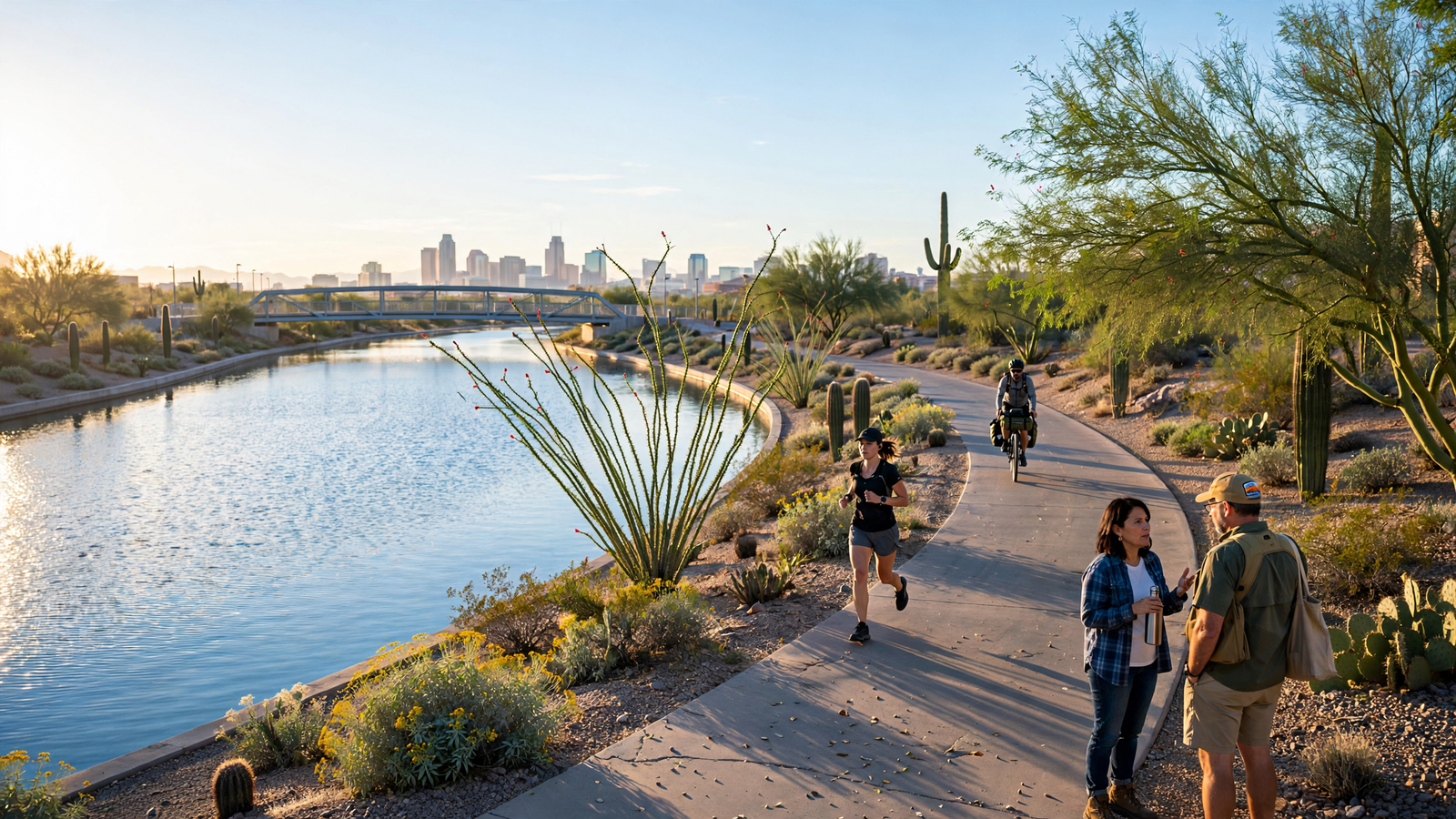
The Grand Canal is one of those places. Built to carry irrigation water across the Salt River Valley, it now serves another purpose alongside its original one. Its edges are becoming part of an expanding network of paths and public spaces known as the Grand Canalscape, giving residents a place to walk, ride, exercise, commute, and see the city from a different angle. For related reading, see South Central Phoenix’s New Rail Line: How a Transit Project Is Rewriting Everyday Distance.
The project is not a single monumental park. It is a linear landscape assembled across neighborhoods, road crossings, commercial areas, schools, parks, and residential streets. That is precisely what makes it important to everyday life. Instead of asking people to travel across town to reach a recreational destination, the canalscape brings a public route into the city’s existing neighborhoods. For related reading, see The Public Library: How America Turned Reading Into an Everyday Civic Habit.
A working canal with a long memory
The Grand Canal belongs to the Salt River Project’s larger irrigation system, which helped make large-scale agriculture possible in the Valley. The canal system grew out of the effort to manage the Salt River and distribute water to farms and communities. The Arizona Canal, Grand Canal, and other waterways helped transform a desert basin into a productive agricultural region before the modern metropolitan area took shape around them.
That history remains visible in the canal’s physical character. The waterway is not ornamental. It is part of an active system that continues to move water. The concrete channel, gates, embankments, and maintenance areas reflect engineering decisions made for reliability and control rather than for leisurely public use.
Yet the same linear form that makes a canal efficient for water delivery also makes it valuable as a potential route. It crosses a wide portion of Phoenix without following the congestion and interruptions of ordinary streets. Where access is improved and safety concerns are addressed, the canal edge can function as a continuous public corridor.
What the Grand Canalscape adds
The Grand Canalscape is generally described as a roughly 12-mile multi-use corridor following the Grand Canal through central Phoenix. Its purpose is to make the canal more accessible while linking destinations that already matter to residents: neighborhoods, schools, parks, businesses, and transportation connections.
Some sections are more polished than others. A person using the corridor may encounter paved paths, bridges, landscaping, benches, public art, street crossings, and stretches that still feel primarily utilitarian. That unevenness is part of the project’s story. The canalscape is not a new landscape created all at once; it is a gradual effort to coordinate public access along an existing piece of infrastructure.
The result is a type of public space that feels different from a conventional park. A park usually asks visitors to arrive and stay. A canal path can do that, too, but it is especially useful for movement. It can be a place for a morning walk, a bicycle trip to a nearby business, a short break between errands, or an informal route to a school or neighborhood gathering place.
That flexibility matters in a city where distance and heat shape daily decisions. A route does not have to replace the car for every trip to be useful. It can simply make one short journey easier without a vehicle, or give residents a safer and more pleasant alternative to walking beside a busy arterial street.
Public space in a hot city
Phoenix’s climate makes the design of outdoor space unusually consequential. A path that is comfortable in the morning can become difficult in the afternoon, particularly during the hottest months. Shade, drinking water, seating, lighting, crossings, and access to nearby destinations all influence whether a route feels like a genuine part of daily life or merely an attractive idea on a map.
The Grand Canalscape cannot solve the city’s heat challenges by itself, and not every segment offers the same level of comfort. But its development reflects a broader shift in how Phoenix thinks about public infrastructure. Canals are no longer seen only as channels that divide neighborhoods or as restricted utility corridors. With careful planning, they can also support walking, recreation, landscaping, and connections between places that have long been separated by wide roads.
This approach has practical advantages. A canal corridor already has a defined path through the city. Improving its edges can sometimes create a meaningful public benefit without acquiring an entirely new strip of land. It also gives residents a way to experience familiar neighborhoods through a quieter, slower-moving landscape.
A route through several versions of Phoenix
Following the Grand Canal means moving through more than one Phoenix. The eastern portions pass through established neighborhoods and areas shaped by the city’s earlier growth. Farther west, the corridor encounters commercial districts, major roads, newer development, and landscapes where the agricultural past can be harder to see.
The canal provides continuity across those differences. It is a physical thread connecting parts of the city that may otherwise feel disconnected. The path does not erase those differences, but it lets people move through them at a human pace.
That experience can reveal details that are easy to miss from a car: the geometry of a bridge, the sound of water moving through a control structure, a line of mature trees, a small pocket of shade, or the way a residential street meets the canal edge. The city becomes less like a collection of destinations and more like a connected sequence of everyday places.
There is also value in the canal’s layered identity. It is simultaneously a water-delivery system, a remnant of the Valley’s agricultural history, a piece of civic infrastructure, and a modern recreational corridor. Those roles do not always fit neatly together, but their coexistence gives the place depth.
Why small connections matter
Large urban projects are often judged by dramatic images: a new building, a signature bridge, or a redesigned plaza. Linear projects are harder to summarize because their success is distributed. It may appear as a person walking to a nearby park, a family riding together on a weekend, or a resident finding a calmer route through the neighborhood.
The Grand Canalscape belongs to that quieter category of improvement. Its contribution is not that it turns the canal into a destination for everyone. Its contribution is that it gives more people a reason and a means to use a landscape that was already running through the city.
That distinction is important. Everyday public space does not need to be spectacular to be valuable. A path can earn its place through repetition: the same walk taken after dinner, the same bicycle ride to a nearby errand, the same shaded bench used during a break, the same route that helps a neighborhood feel connected to the next one.
The future along the water
The Grand Canalscape is best understood as an ongoing civic project rather than a finished object. Its future depends on maintenance, safe crossings, thoughtful landscaping, coordination among public agencies, and continued attention to the needs of people who walk and ride rather than drive.
It also depends on recognizing the canal for what it is. The waterway cannot simply be treated as a decorative feature. Its operational role, safety requirements, and environmental conditions must remain central. Public access works when recreation is designed around the canal’s primary purpose, not when the water system is forced to become something it is not.
That balance may be the project’s most useful lesson. Phoenix does not have to choose between preserving practical infrastructure and creating more inviting public places. In the right circumstances, the same corridor can do both.
The Grand Canal still carries water through the Valley, as it was designed to do. But along its edges, Phoenix is adding another kind of flow: people moving through the city on foot and by bicycle, connecting neighborhoods, noticing the landscape, and making an old piece of infrastructure part of contemporary everyday life.
Use: Project scope, public access, and the Grand Canalscape’s role as a multi-use path through Phoenix.
Use: Background on the canal system, irrigation infrastructure, and the continuing operational role of Valley canals.
Use: Information about public recreation and trail access along selected SRP canal corridors.
City of Phoenix Parks and Recreation — Grand Canalscape — https://www.phoenix.gov/parks/trails/paths/grand-canalscape — Project scope, public access, and the Grand Canalscape’s role as a multi-use path through Phoenix.
Salt River Project — Canals and Water Management — https://www.srpnet.com/grid-water-management/water-management/canals — Background on the canal system, irrigation infrastructure, and the continuing operational role of Valley canals.
Salt River Project — Canal Trails — https://www.srpnet.com/grid-water-management/water-management/canals/canal-trails — Information about public recreation and trail access along selected SRP canal corridors.